The Wabena Trail is one of the most scenic
trails in the North Fork American canyon.
This unmarked, unmaintained trail descends into the Royal Gorge.
The trailhead is at about 6350 feet, the river, about 3800 feet,
making for a difference in elevation of 2550 feet. The trail is
badly overgrown and difficult to follow. This trail provides the
easiest access to Wabena Falls, below.
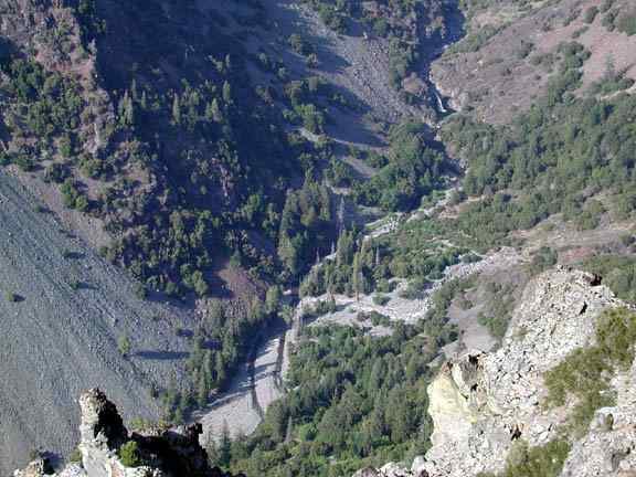
Wabena Falls, as seen from Wildcat Point,
3000 feet above and a mile west. The Wabena Trail descends to
the river near the center of the photo.
Below, two maps of the area. Access is by way
of the Foresthill-Soda Springs road, and the trailhead is about
ten miles east of Robinson Flat, and fifteen miles from Soda Springs.
A spur road leads to a small parking area immediately below the
main road, with a large fallen tree and a rock fire ring.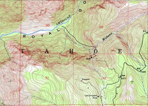
A portion of the 7.5 minute USGS Royal Gorge
quadrangle. The Wabena Trail descends from a point surveyed at
6371 feet in elevation on the Foresthill-Soda Springs Road (lower
right). Wildcat Point is to the west in Section 31, Snow Mountain
to the north across the river. The Wabena Point petroglyph site
is on the ridge crest in the upper right. The lower part of the
Wabena Trail does not show on the USGS quadrangle; I drew its
course in, roughly. Wabena Falls is between the "N"
in "American" and the "G" in "Gorge,"
on the North Fork.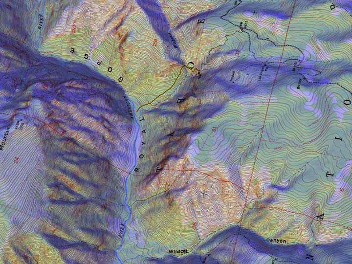
An experiment in map-making. Here is an
oblique view of the Wabena Trail/Wabena Falls area from the west
and above, but looking not due east, but slightly north of east.
A mesh of several hundred thousand triangles is fitted to the
landscape (using POV-Ray's height_field function, based upon the
Royal Gorge DEM), and to this mesh, a scan of the Royal Gorge
quadrangle is applied. The scene is illuminated by a blue light
straight overhead, and a yellow light due west elevated about
30 degrees above the horizon. North is to the left and up. The
word "Snow" in "Snow Mountain" is just off
the map. I drew in the missing part of the Wabena Trail with a
broader yellow line and a narrow black line within it, in PhotoShop.
Note, on the west side of Wildcat Canyon, bottom right, the trail
leading past Sailor Meadow to the Walker Mine. This trail too
continues down to the North Fork.
Below, a few photos taken along the trail.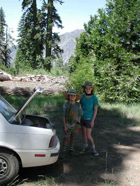
At the trailhead, Greg and Janet Towle are
wearing shorts--a big mistake, and my fault. Too much brush for
shorts on this trail!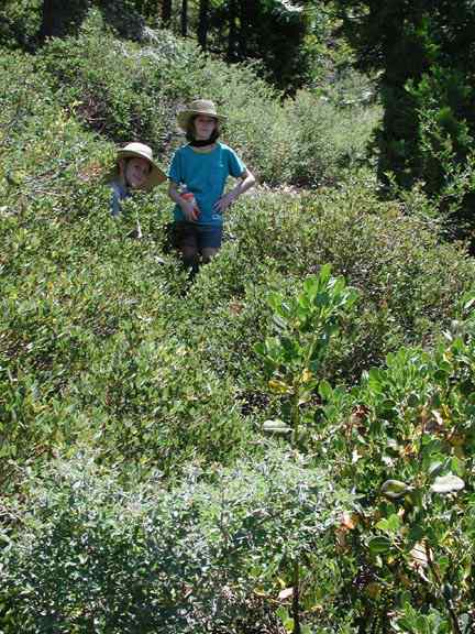
A typical reach of the Wabena Trail.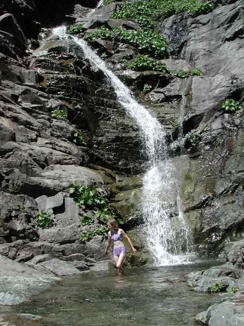
About 1000 feet above the river, and 1500
feet below the trailhead, the trail crosses Wabena Creek, at about
4800 feet in elevation. Suddenly, Canyon Live Oaks appear, California
Bay Laurel, and Poison Oak, where just a half mile up the trail
one finds Western Junipers! Several high waterfalls are on the
creek, here, on July 12th, 2001, a dry year, at a low flow.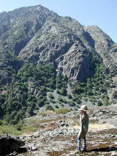
Descending past Wabena Creek, the trail
crosses a number of rock slides, and then breaks out onto a glaciated
surface, with fine views across to Snow Mountain, and down the
canyon to Wildcat Point and Big Valley Bluff. This is as far as
we got; the brush had caused us to lose the trail a few times,
and it took longer, much longer, than I had imagined, to reach
the crossing of Wabena Creek.
On August 2, 2001, Luc Olrich and I made it
down to Wabena Falls. A description of our hike is found below,
but first, some photos.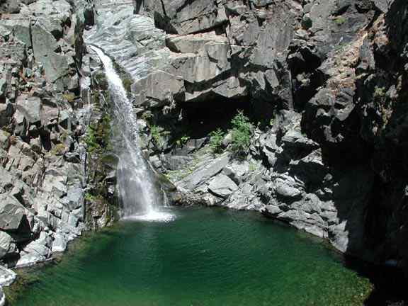
From the encircling cliffs, looking down
on the falls and pool.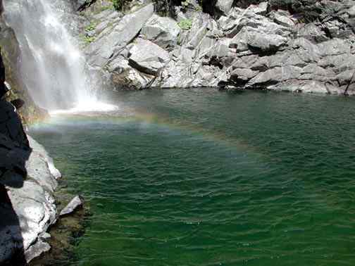
Even in August of a dry year, the falls
generate enough mist to see a rainbow.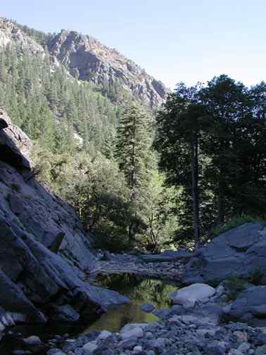
From the falls, one can see Wildcat Point,
3000 feet above, on the south wall of the North Fork American
canyon. Compare this with the photo at the top of the page.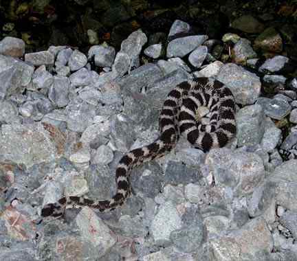
There is a healthy population of rattlesnakes
in the Royal Gorge. This one may have had a recent meal.
The most conspicuous Water Ouzel nest I
have ever seen. The entrance is in the shadowed lower portion
of the nest, facing the camera.
The Indian Ouzels of Wabena Falls
Yesterday young Luc Olrich (23) and I made
a visit to Wabena Falls, in the
Royal Gorge of the North Fork American River. We met in Colfax
and made the
long drive, by way of Iowa Hill and Sugar Pine reservoir, over
to the
Foresthill/Soda Springs road, then up and up and up, perhaps ten
miles past
Robinson Flat, to the unmarked trailhead, near a point surveyed
at 6371
feet in elevation, in the upper west basin of Wabena Creek. Wildcat
Point,
just to the west on our side of the canyon (the south side), stands
3000
feet above the river, while across the canyon, the massive bulk
of Snow
Mountain lifts a gigantic expanse of bladed cliffs over 4000 feet
above the
river.
By a quirk of fate Luc and I both have home-made
metal-handled loppers, and
we set off down the trail planning to open up some of the worst
sections.
We wore long pants, a necessity, and we each cut around two or
three
hundred branches. Later, on the way back up and out, I remarked
to Luc that
it was as if we had done nothing. That is one badly overgrown
trail.
I made the mistake of over-lopping, and started
to feel kind of shaky and
over-heated from the exertion. I knew I should stop, to conserve
energy for
the hike, generally, but really nasty branches kept getting in
my way.
Sweat streamed into my eyes.
We paused at the crossing of Wabena Creek,
with its lovely waterfalls, and
pools swarming with trout. Continuing down toward the river, we
noted how
the trail is sometimes well-defined, sometimes invisible save
for the rock
ducks left by other hikers. We wished to establish the course
of a high
trail making a shortcut to Wabena Falls, and veered away from
the main
trail at a certain point, to follow a more northeastern course.
There are some curious springs nestled in a
patch of forest there, and at
the base of a large ponderosa pine, ca. four feet in diameter
with a huge
basal mound, we came across the most perfectly-formed bear bed
I have ever
seen. It was like a giant bird's nest, four or five feet across
and near
two feet deep, with a well-defined rim about a foot high all the
way
around. A perfect circle.
We tried to conserve elevation and succeeded
too well, finding ourselves
three or four hundred feet above the falls with a long stretch
of angular,
shifting talus to descend. Soon enough we reached the brink of
the cliffs
which almost encircle Wabena Falls and the huge, deep pool at
its base.
Here, at 3800 feet in elevation, there is a lot of glacial smoothing
of the
Jurassic intrusives which compose the eastern half of Snow Mountain,
and
much of Wabena Point. Locally, the joints in the rock (a fine-grained
diorite) are less closely-spaced, making them resist glacial plucking
better. Perhaps the most dominant joint planes run athwart the
canyon, and
are almost vertical, making for spur ridges which converge from
either side
upon a waterfall and pool, at such places.
We admired the falls and the nearly circular
and very deep pool, ranging
from emerald green to almost black in color, and sparkling brightly
in the
noonday sun. Being hot and tired, it was imperative to reach the
pool soon,
and not caring to make the 100-foot jump, we followed along the
edge of the
cliffs westward until a heavily beaten game trail led us to the
only
feasible place to descend. I was in the lead, and while negotiating
a steep
section, studded with boulders enmeshed in the roots of an ancient
live
oak, I heard a sudden buzzing rattle, very brief, and almost serene.
A
rattlesnake sprawled a few feet below me. It did not seem too
concerned
about my presence. I offered a few words of reassurance, something
like,
"Take it easy, big fellow, I'll stay well clear," and
picked my way past.
As Luc followed, the snake disappeared into a tiny hole in the
mossy steep
threaded with oak roots.
At the river, just below, we found that the
falls are well hidden. There is
a short bend in the gorge just below the falls, and nothing to
indicate
that one of the great jewels of the Royal Gorge is but a few steps
upstream. We arrived in short order and within a matter of seconds
the
clothes were gone and we plunged into the water. It was surprisingly
cold,
similar to the water of the Pool of Cold Fire in the North Fork
of the
North Fork. We each swam to where the falls plunge into the pool,
but
neither of us dared to swim directly beneath them. Low as the
river is, in
this unusually dry year, to be hit on the head by masses of water
which
have fallen forty or fifty feet clear is not pleasant.
Emerging from the pool, Luc discovered the
carcass of a large owl or some
type of raptor. The sharp claws were there, but no head. We found
some
shade along the cliffs and ate lunch. Afterwards, I suggested
a ramble
upstream; there were some other large waterfalls, I said, perhaps
a quarter
or half a mile up. We left our packs in the shade and started
up and over
the cliffs. After a while a way presented itself to return to
the river,
and we followed it up until another pair of spur ridges, meeting
at a
smaller waterfall with a very nice and deep pool, forced us to
climb up and
around again.
The entire Royal Gorge area is full of large
talus slides and debris
aprons, some of which are simply monstrous, and have been developing
for
thousands of years. Again and again I saw signs of major avalanches
of
talus which had briefly dammed the river and then been breached,
during the
January 1997 flood event. It is quite remarkable how fresh many
of these
areas look to this day. In some places, small rocks and sand remain
atop of
boulders well away from the river, and twenty feet or so above
its level,
being vestiges of a rockslide which had filled the channel to
that depth
and who know how much more, before being ripped away by the raging
flood.
At one place, very large avalanche, perhaps of mixed snow and
rock, had
fallen from high on Wabena Point. I could go on and on about the
almost
desert-like wastelands of angular boulders and avalanche sediments,
which
look as raw and fresh as if they had happened yesterday; they
are entirely
uncolonized by new vegetation.
We admired the many boulders of marble found
along this stretch of the
river, which come from a small body of the same a few miles upstream,
near
Heath Springs. They range from sparkling sugar white, to banded
and mottled
blue-gray in color. When struck by another rock, they smell of
sulphur,
like a match. There are many huge erratics of granite from the
Palisade
Creek area littering this part of the canyon, as well as large
masses of
diorite from the flanking cliffs, and quite an assortment of other
rock
types, including some meta-mudflow.
My "quarter of a mile" became half
a mile with no sign of a big waterfall.
Still, we hopped along, boulder to boulder, or sometimes walking
the small
gravel bars. At a certain point I almost blundered over another
rattlesnake. It did not rattle, but became unnerved and began
to slither
rapidly away. It made for a boulder and started up the side. "What,
you
think you're going right up and over that thing?," I asked
the snake
incredulously. Embarassed, it stopped, halfway up the steep side
of the
boulder. We left it to work things out in peace, and after a time
a reddish
spur ridge came into view another ways upstream. I recognized
it as the one
flanking the big falls. So, we forged ahead, and reached the falls,
and the
lovely deep deep pool. These are the two-tiered, double falls
one sees from
Wabena Point, at the petroglyphs. Luc swam again, I got my feet
wet. The
sun was hiding behind Snow Mountain as the afternoon waned, and
I just
wasn't quite ready to brave the cold water with no sun to warm
me when I
got out.
We had more than a mile to go to reach our
packs, and soon started back
down the river. All afternoon we had been herding water ouzels
along the
river; they were constantly fluttering on ahead of us, and every
single
rock near the water's edge was dotted with their poop. While hopping
across
a group of rather large boulders in the bed of the river, six
to ten feet
across, I found the most amazing water ouzel nest I have ever
seen. It was
built right on top of a large boulder, in plain view. It was like
a little
Indian house or some such thing, a perfect dome of moss and grasses,
with a
neat little entrance hole facing the water. Usually ouzel nests
are on
cliffs beside waterfalls, and cunningly located so as to be nearly
invisible, and always to be inaccessible to rats and snakes. This
nest
seemed to have no such protection, although the sides of the boulder
were
steep. Luc suggested that perhaps during nesting season, the river
had been
higher, and surrounded the boulder on all sides.
I took some photos and will put one up on my Wabena Trail web page soon.
Hopping and hopping we continued downstream
Luc gave a sudden shout and
made an awkward landing; he had had to change his jump in mid-air,
to avoid
a tightly coiled rattlesnake, missing it by a couple of inches
and dancing
past. This snake seemed reluctant to uncoil, but as I photographed
it, it
suddenly decided to charge us down, and we left, discretion being
the
better part, and so on.
We repeated the same ups and downs to pass
the various falls in reverse
order and regained our packs. After a break, we followed the river
down to
the confluence of Wabena Creek. Here there was the largest
desert-of-angular-boulders yet. Wabena Creek had apparently become
a
violent unstoppable force in its own right, in January of 1997,
and several
acres of ground had been completely ravaged. Here also, the North
Fork
seeps underground, with no surface flow at all this time of the
year. This
is just upstream from one of the tremendous debris aprons on Snow
Mountain,
plainly visible from the confluence. Wabena Creek itself also
flows
underground here. There is such a deep accumulation of avalanche
debris
here, that during low flows the water simply sinks well below
the surface.
The sun was also sinking, so we scouted along
beside Wabena Creek until we
found the trail, such as it is. The climb up to the crossing of
Wabena
Creek, about a thousand feet higher and a mile away, was brutal,
in the
full sun. I must admit I was pretty well thrashed by the day's
exercise. We
had a long rest at the Wabena crossing, filled our water bottles
right from
the creek, and continued up. The sun had lowered enough so that
we were now
in shade, only the ridgecrests above still holding light. This
made the
climb much, much easier. I stopped wishing I had never been born,
etc.
etc., and we slogged along patiently, while the sun set and night
came on.
A full moon would offer no help for hours, so we more or less
stayed the
course and made the trailhead in the last vestiges of the twilight.
Driving
out, we arrived back in Colfax a little after eleven.
It was a marvelous hike to a marvelous place,
and even when we do get the
brush cut back from the trail, it will be a rough tough go and
few will be
the people who will dare the descent, to swim the magic pools,
herd the
ouzels, and bother the rattlesnakes.
Back to the North Fork American page