Geology
Having nurtured an interest in geology since
childhood, in the course of hiking and skiing thousands of miles
throughout California's Sierra Nevada, I have always tried to
develop some kind of geological perspective. I am particularly
interested in the evolution of landforms, and in the theory of
plate tectonics.
For all the learned papers published every
year about Sierran geology, much remains to be disovered and properly
understood. I wish every geology student could grasp the magnitude
of the opportunity here; there is a vast amount of research, bearing
upon some of the most interesting, and even pivotal issues, left
undone.
The bedrock geology of the Sierra presents
such a challenge. A complex of metamorphosed sedimentary and volcanic
rocks, Paleozoic and Mesozoic in age, has been intruded by hundreds
or thousands of granitic plutons. These granites date from Mesozoic
and Cretaceous times. It is notable that the metamorphic rocks
occur in linear zones, often in faulted contact with their neighbors,
striking northwest, parallel to the Sierra crest and Central Valley.
The granites cut across the contacts and fault zones of these
older metamorphic rocks.
Very well; the plate-tectonic interpretation
of the above, is that the westward drift of the North American
plate of the earth's crust, combined with the eastward drift of
the Pacific plate, resulted in the subduction of the basaltic,
oceanic crust of the latter, beneath the lighter, quasi-granitic
continental crust of the former. Parts of the marine sediments
lying atop the ocean floor, portions of coral reefs and such-like
calcareous, marine deposits, and parts of the basaltic ocean floor
itself, are conceived to have been scraped off against the western
margin of North American. Over the course of perhaps 100 million
years, this scraping-off built up the continental margin, extending
it dozens of miles west. All this happened deep below the surface,
and under sufficient heat and pressure that the rocks involved
were metamorphosed.
So much for the broad outlines; in detail,
the picture is blurred and considerable work will be required
to attain a reasonable focus. The very ages of the linear zones
of metasediments and metavolcanics, and the directions of displacement
along the many fault zones associated with these rocks, are very
poorly known. A friend of mine, Davy Jones, formerly a professor
at Berkeley, has made some progress in these areas. Davy has been
able to date some of the metamorphic rocks by identifying species
of radiolaria found in chert.
Much of the northern and central Sierra was inundated
by rhyolite ash and andesitic mudflows in the Miocene and Pliocene.
The Valley Springs and Mehrten formations are the respective types
of these classes of deposits. These volcanic materials (the sources
of which, are poorly understood) largely buried the landscape
of the ancestral Sierra. In the Eocene, this landscape was characterized
by broad, sluggish rivers, meandering over floodplains between
low, rounded ridges. These ridges, representing the toughest of
the zones of metamorphic rock, followed the strike of these zones,
northwest/southeast.
Just as the last of this wholesale burial was
being completed, the Sierran block broke free from rocks to the
east and began to tilt to the southwest, like a giant trap door
with its hinges beneath the Central Valley. The uplift seems to
have greater in the south, upwards of 10,000 feet, and less in
the north, perhaps 5,000 feet. That the Sierra has behaved like
a rigid block is evidenced by the uniform increase in elevation
of the crest, which goes from around 7,000 feet in the north,
to over 14,000 feet in the south. The uplift continues to this
day, with active faults extending the length of the Sierra, at
the base of its steep eastern slope.
The rapid uplift of the Sierran block imparted
a southwestern tilt to the plateau of volcanics which had buried
the more northern region. A series of streams were incised into
this plateau, and rather quickly cut through the weak volcanics
and into the much older granites and metamorphic rocks below.
Simultaneously, the onset of glaciation in the Pleistocene not
only helped strip away the volcanic cover, where it had been deepest
(in the higher elevations), but added huge amounts of meltwater
with abundant sediment loads, to the newly-formed streams on the
western slope. Thus the new canyons were quickly entrenched, and
today are often two or three thousand feet deep. The degree of
erosion is such that, remnants of the andesitic plateau are found
upon nearly every one of the ridges dividing major canyons, in
the northern Sierra.
With practice, anyone can learn to identify
these mudflow-capped ridges at a glance. Especially in the middle
elevations of the northern Sierra, all of the major canyons present
a cross-section of the two ubitquitous volcanic formations, although
the rhyolite ash is not often directly visible. It is so weak,
and offers so little resistance to erosion, that it is usually
blanketed by soils. This ash layer supports a perched water table,
and a discerning eye can often identify it merely by the vegetation,
which is typical of moist areas. That is, dogwoods, maples, and
even whilte alders will be found growing on this ash layer.
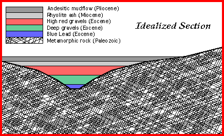
Typically, the Paleozoic or Mesozoic bedrock
lies directly beneath the Miocene rhyolite ash. Often the vegetation
changes abruptly here, and one can easily trace the contact between
the soft, wet volcanics, and the underlying slates and serpentines
and greenstones, from a distance of several miles. If this bedrock
/ volcanics contact is seen to dip to a lower elevation, locally,
this will often mark the course of one of the Eocene channels,
and the complete section of Eocene gravels and younger volcanics
can be seen.
More on geology
can be found in my pages on the North
Fork of the American river.
Back to Russell Towle's
homepage.