The Geology of Green Valley and its Unusual Quaternary Gravels
The Mining History of Green Valley
One of the fabled mining camps of old Placer County was Green Valley, on the North Fork of the American River. Here, the Great American Canyon widens into a vast amphitheater, in the sheared and shattered serpentine of the Melones Fault Zone. To the west, a great wall of massive greenstone almost closes Green Valley away from the outside world. The mighty wall is riven by a narrow gorge, called Giant Gap.
The topographic contrast is extreme. Not only is the canyon at large over 2000 feet deep, but that its widest widening, and narrowest narrowing, should be juxtaposed so directly, begins to inspire awe. Then add to that, the bold, convex-upward cliff called Lovers Leap, which thrusts into Giant Gap from the north, and its sister structure to the south, a concave-upward spur ridge, studded with pinnacles, like so many inscrutable totems and obelisks--add all this, and at once you begin to have a canyon of truly divine proportions.
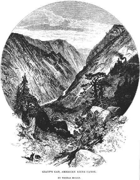
Thomas Moran's 1876 etching of Green Valley and Giant Gap. The Pyramid, or Knoll 2277, can be seen near the center, blocking our view of a bit of the North Fork. The view is from above Green Valley to the east, near Iron Point. Note, on the right, a steam engine of the CPRR, rounding the bend at Eureka Cut, now known as Casa Loma. Lovers Leap is visible in the right background, The Pinnacles, left background. A Golden Eagle soars on the left, near trees in the foreground.
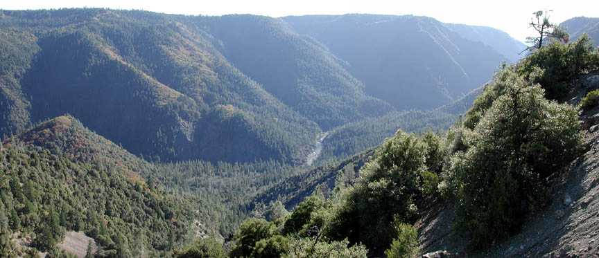
A panoramic view of Green Valley, taken from near Casa Loma on the north canyon rim. Giant Gap is in the right background, to the southwest.
For this reason, there was once upon a time a movement--in the 1860s--to rename Giant Gap, "Jehovah Gap," but the old name, dating to 1849, won through. But there is more, much more, of note in this strange and poetic landscape. There are, for instance, several knolls. One, near the west end of the valley, has an elevation of 2277 feet. I call this one, "The Pyramid," because the eccentric Dr. Wallace Halsey--who believed that aliens had visited Earth repeatedly to foster civilization and spiritual growth, and had taught we humans to build pyramids--Dr. Halsey declared this knoll to be one of two such ancient, alien pyramids in the state of California. He seems to have set this idea forward around 1960. I myself will have none of it, but I do like the name. In fact, although Halsey's disciples have explicitly idenitifed Knoll 2277 as his supposed pyramid, my own reading of the pertinent document suggests that Halsey intended another of Green Valley's knolls for this honor.
Howsoever: rather than Knoll 2277, I call it The Pyramid. A lower knoll stands a little to the east, and a much higher knoll rears up across the river still farther east. It is labeled Snakehead Point, on the USGS 7.5 minute Dutch Flat quadrangle--of this one I shall have much to say, below--and finally, a fourth knoll guards the east end of the valley.
I should say here, that knolls within Sierra canyons are not all that common. More typically, from canyon rim to river, there is a continuous descent, without interruption. Green Valley is not typical. I have devoted considerable time over the years to studying and pondering the geology of Green Valley, and much of this page will be devoted to geology. In particular, the Ice Age, Quaternary gravels of Green Valley deserve special attention. They are deep and they are high and they can, and someday will, be correlated with discrete glacial advances in the upper North Fork.
The history and prehistory of Green Valley have likewise interested me. After years of searching, I have found only the most rudimentary testimony about the early days of gold mining in Green Valley, when 2000 people lived there, and the place was supplied by mule trains coming up the divide between the Bear and North Fork, from Illinoistown. I have better primary materials bearing upon later phases of its mining history, in the 1860s and especially, the 1870s.
The North Fork American is a strong river, capable of moving large quantities of coarse sediment. For example, millions of cubic yards of rock and sand and clay were dumped into the North Fork from the hydraulic mines of Gold Run, from 1860 to 1882; one could drive a wagon up the surface of the "tailings" all the way to Canyon Creek from the Iowa Hill Bridge at Mineral Bar, ten miles downstream. Almost every vestige of these mine tailings have long since been ripped away, and carried away downstream to who knows where. Yet, given a certain gradient and a certain flow, if one increases the sediment load in a river, at some point it will begin to deposit those sediments, rather than carry them away. In the North Fork American, as in the South Yuba and all other major Sierran canyons, periods of glaciation meant vastly increased sediment loads. Below the terminus of the North Fork glacier (near Humbug Canyon, six miles upstream), some 15 or 20 thousands years ago, a long and narrow glacial outwash plain formed, covering the bedrock channel of the river The North Fork now meandered over boulders and cobbles and sands; it meandered narrowly where the canyon was narrow, and it meandered widely where the canyon was wide.
In Green Valley, the canyon was wider than anywhere else, and the North Fork lashed its meanders back and forth across this width, attacking the canyon's walls and widening it still further. Then the glacier retreated, it melted back higher and higher into the upper canyon and then it was gone; and as it melted away, the sediment loads decreased below that critical level, and the North Fork began incising its channel deeply into the glacial outwash. Remnants of this outwash, from the most recent glaciation, exist far down the canyon, all the way down to the Great Central Valley. The remnants form terraces or benches, usually on but one side or another of the river, but sometimes in terrace pairs, on both sides. These terraces stand fifty feet or so above the river. They are the "bars" made famous during the Gold Rush, although few people seem to have understood then, or to understand even now, that these terraces have nothing to do with the current flow and sediment regime of the North Fork; they are artifacts of the last glaciation, pure and simple.
This filling-with-glacial-outwash, this subsequent down-cutting and stranding of terraces, did not happen once, but happened many times. We do not know just how many. And in Green Valley, where the canyon is wider, and the river's meandering course painted a broader canvas than elsewhere, the glacial outwash gravels seem also to have been deeper than they were, elsewhere. For goodness' sake, they were hydraulically mined! But, more than that, the very width, the broad extent of the great canyon, in this one peculiar area, seems to have protected fragments of terraces and masses of outwash much older than is usually the case. Some of these sediments stand fully 600 feet above the river. In what follows, I attempt to describe not only these unusual gravels, but the geological setting in which they are found.
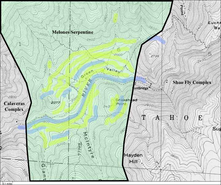
A very crude geological map of Green Valley, in the canyon of the North Fork of the American River near Dutch Flat, California. No attempt has been made to depict areas covered by the Tertiary gravels and volcanics (Valley Springs and Mehrten fms.), which are present on the upper left and lower right of the map, mostly above the 3800-foot contour. Incidentally, the map was made from a portion of the USGS 7.5 minute Dutch Flat quadrangle.
Three main bedrock units are shown: in the center, the serpentine of the Melones Fault Zone (the fault itself forming the right-hand boundary), in a light green. This serpentine is one of the longest uninterrupted bedrock structures in the Sierra, and trends roughly parallel to the Sierra crest and thus at right angles to the various canyons. To the west, a little of the Calaveras Complex rocks are seen; these are the massive meta-tuffs (?) of Giant Gap, and are in faulted contact with the serpentine. A few miles farther west are the metasediments of this same Calaveras Complex. To the east are rocks of the Shoo Fly Complex, the oldest rocks in the Sierra, around 400 million years old. These also are in faulted contact with the serpentine.
The blue streaks represent, in the most approximate fashion, various Quaternary relict channels of the North Fork American. The yellow streaks show areas of Quaternary sediments. Note the yellow at Snakehead Point; these are the high gravels at the Hayden Hill Mine, which stand fully 600 feet above the river, and are likely the oldest of all the Quaternary sediments in Green Valley.
The Pyramid--elevation 2277 feet--is visible, as are all the bedrock knolls mentioned above. Several of the trails shown, and the footbridge, seem to be out-and-out errors of the USGS. The last footbridge in Green Valley was a crude suspension bridge, which crossed the river a mile or so west of the spurious bridge on the map, not far from The Pyramid.
A more complete discussion of the geology
is found below.
There is an almost strangely insular quality to the North Fork American canyon. It is such a world unto itself, and seems only rarely to be penetrated by tributary canyons which could, if followed, lead into other worlds. One of the exceptions to that rule is but a mile upstream from Green Valley, where the North Fork of the North Fork American enters from the north. Between the two canyons stands Sawtooth Ridge, or what I.T. Coffin of Dutch Flat used to call the "Camel Hump-Backed Ridge." It is not a terribly sharp-toothed ridge, and deserves its name more out of contrast with the ridges nearby; for most of these are flat-topped remnants of the old (actually, young) volcanic mudflow plateau.
If you are unfamiliar with the broad outlines of the local geology, you may wish to go to my Geology of the North Fork American page, and then return here. To summarize: The bedrock of this part of the Sierra is arranged in linear structures parallel to the crest of the range. These rocks are old, and near Green Valley are all metamorphic rocks. The famous granite of John Muir's Range of Light is not often seen in the North Fork American. Around 55 million years ago, the "ancestral" Sierra, a fairly subdued and long-worn-down landscape, was drained by sluggish rivers meandering over their own deep beds of sediments, and debouching into the ocean where today we have the Central Valley. Beginning about 30 m.y.b.p. (million years before the present), volcanoes east of the ancestral Sierra erupted large quantities of rhylolite ash, which tended to bury the sluggish rivers and caused them to seek new channels. Subsequently, great volumes of andesitic mudflows spread over the area, and finished the job the rhyolite ash began. The old Eocene rivers were dead and buried, as were most all the ridges dividing them. The period of andesitic vulcanism stopped but a few million years ago. Then the Sierra was uplifted, en masse, like a huge trap door four hundred miles long, sloping toward the Central Valley. This happened bit by bit over the last few million years, and as it happened, the climate cooled and glaciers formed in the high country. Sediments called glacial till have been found beneath lava flows dated to 2.9 m.y.b.p. near Mammoth, for instance.
This burial of the ancient landscape by the young volcanics did not happen in the Southern Sierra. Here in the Northern Sierra, the generalized andesitic mudflow plateau was soon dissected by streams flowing to the southwest, or directly downhill, as it were. The present canyons, often 2000 feet deep, are described as "consequent upon" this southwest-sloping mudflow plateau.
As glaciers waxed and waned, great quantities of meltwater were supplied to the nascent canyons, which rather quickly incised their "consequent" courses through the soft volcanic strata, and into the bedrock beneath. From a geomorphological standpoint, today's canyons are regarded as "youthful," with their steep sides, and their rivers flowing in channels incised directly in the bedrock. Another sign of their youthfulness is that portions of the volcanic plateau, into which the canyons were initially cut, remain intact, forming the flat-topped ridges so conspicuous in the middle elevations of the Northern Sierra. This is true of the ridges flanking Green Valley.
The Eocene-age channels of the ancestral Sierra are also preserved in places, on the divides between the major canyons. A few miles to the west of Green Valley is the channel of the South Branch of the Tertiary Yuba, where a 400-foot-thick section of gravels is exposed in the hydraulic mines of Gold Run. At their base, these gravels are Eocene in age; but near the top of the section, they are associated with the Miocene-age rhyolite ash of the Valley Springs Formation, and the Mio-Pliocene andesitic mudflows of the Mehrten Formation. The base of the channel is at 2800 feet in elevation, where it is cut by the North Fork canyon, and the river below is at about 1600 feet in elevation.
Please note that here, near Gold Run, the present river has incised its canyon only 1200 feet below the deepest incision in the ancestral, pre-volcanic landscape.
Near Green Valley the contrast is more extreme. Eocene (?) and probable Miocene "intervolcanic" channels flank the North Fork American on both sides of the canyon, but the bedrock floors of these Tertiary channels are at about 3800 feet in elevation, and therefore, at least locally, the North Fork has cut down fully 2000 feet below the lowest low ground of the ancestral landscape.
Below is a "longitudinal" section of the rocks near Green Valley, taken parallel to the course of the canyon, i.e., along a vertical plane trending northeast-southwest.
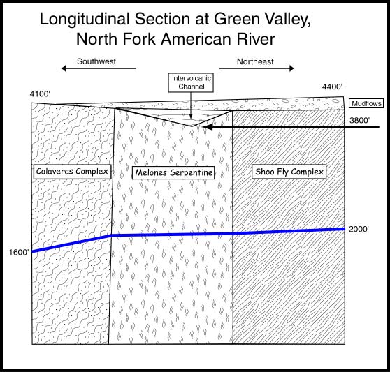
The blue line represents the course of the North Fork American, as projected onto the plane of the section. Note that the gradient of the North Fork is steep in Giant Gap, where the river has cut a narrow gorge in the massive meta-volcanics of the Calaveras Complex. In the Melones serpentine the river's gradient is nearly flat, while to the right (upstream), it steepens slightly.
When we say a rock formation is "massive," we mean that it is relatively free of joints, or that the joints are widely spaced. This is true of the Calaveras metavolcanics of Giant Gap. In contrast, the serpentine is far from massive; it is riddled with thousands of joints, and therefore is readily attacked by mechanical weathering. For instance, water can seep into the joints, which then freezes, hence, expands, and wedges the rocks apart. The Shoo Fly Complex is also well-jointed and not, usually, very massive.
From a geomorphology standpoint, in this youthful canyon, where the river is actively cutting its channel farther down towards base level, one can use river gradient to measure how resistant to erosion are the various rock formations crossed by the river. In my opinion this resistance is almost synonymous with how massive they are, although one can find instances, within the Shoo Fly Complex, where the hardness of the rocks (rather than massiveness alone) may have helped protect them from erosion. Much of the Shoo Fly has a slaty structure, and is easily eroded, but the Duncan Chert, and quartz-rich meta-sandstones nearby, reveal their durabilty by forming great cliffs and eminences.
In the figure above, no attempt has been made to show the Valley Springs rhyolite ash, which underlies the Mehrten mudflows nearly everywhere. The intervolcanic channel depicted is that exposed on the north rim of the canyon east of Moody Ridge. Here one finds a thick sequence of intercalated gravels and volcanic ash, and in fact, the figure is inacurate, for the Mehrten mudflow has been stripped away above the channel itself, leaving a low pass in the ridge dividing the North Fork American from Canyon Creek.
Even where an intervolcanic channel does
not exist to complicate matters, the Valley Springs rhyolite ash
is really made of many discrete layers, of many discrete ages;
and so also with the thicker sequence of andesitic lahars which
almost always covers the rhyolite ash. Very little work has been
done to map and identify these various volcanic units. At higher
elevations, father east, one such unit is a "pink welded
tuff" within the rhyolite sequence. Near Green Valley, most
if not all of the rhyolite ash units seems to have been reworked
and even retransported by water. Some units, however, resemble
welded tuffs, and were so mapped by Dalrymple in 1964.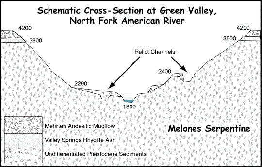
A cross-section at Green Valley, not to
scale; elevations in feet. The contact between the young volcanics
("Superjacent Series") and the underlying serpentine
of the Melones Fault Zone ("Subjacent Series") is an
angular unconformity. Note the Pleistocene sediments at the 2400-foot
level; these are intended to represent those at Snakehead Point,
which, as discussed below, may be Sherwin-age deposits.
The contrast between the massive meta-tuffs of Giant Gap, and the shattered and sheared serpentines of Green Valley, is one of the most striking I have ever seen. The canyon is almost four miles wide across the serpentine, and only one mile wide--but half a mile deep--across the meta-tuff. Thus sections taken at right angles to the river would vary greatly in profile. I made such sections on graph paper in 1975, while trying to comprehend and quantify this astounding contrast in canyon morphology. So far as the aim of this essay goes, I may as well remark now that no Pleistocene (Ice-Age) gravels worth noting have been preserved in Giant Gap; the slopes are too steep. However, in Green Valley, the gentle slopes flanking the river have provided "refugia" in which masses of gravel, of apparently many different ages, have been preserved.
In the caption above I touched upon the various distinct layers of rhyolite ash and andesite mudflows. These volcanic layers accumulated over the course of millions of years, and during intervals between eruptive phases, the topmost, latest layer would be subjected to erosion, and valleys would be incised, only to be filled by detritus from the next eruptive phase. That is, an eruptive sequence would tend to fill existing valleys and flatten the terrain. This, then, would immediately become a new erosion surface, and begin to be dissected by streams. Depending on many factors, these streams might cut down below the level of earlier erosion surfaces, or even down to bedrock; then another eruptive sequence would fill these new valleys, and flatten the landscape once again benath a sea of volcanic debris. This new erosion surface would then begin to be dissected. These various buried erosion surfaces are called "unconformities," and the contact between the young volcanics and the underlying bedrock is called an "angular unconformity," because the underlying metamorphic and igneous rocks we call the "bedrock" either lack any stratigraphic layering (as in the granites), or if they do have a stratigraphy, it is turned up on edge (as in the metamorphic rocks). The volcanic sequences are in roughly horizontal layers. It is somewhat as if one made a multi-layered cake, and then turned it on its side. This represents the metamorphic rocks. Now, spread a layer of white frosting over the new top of the cake, covering the exposed layers; this represents the rhyolite ash sequence. Cover this white frosting with some brown frosting. This represents the andesitic mudflow sequence.
We are about to return to Green Valley's Quaternary
gravels, but first, a word about geological names like "Tertiary"
and "Quaternary." It must be frankly recognized that
these names for the different geological epochs and ages are quite
arbitrary and without much rhyme or reason. One sees at once that
if there is a Tertiary, followed by a Quaternary, then there must
be a Primary and a Secondary, and once upon a time, there were,
but those terms have fallen out of use. The Tertiary is conceived
to span the time from 65 m.y.b.p. (marking the demise of the dinosaurs)
to about 2 m.y.b.p. Why "about"? Because the event by
which we divide the older Tertiary rocks from the younger Quaternary
rocks is the onset of the Ice Age, and "true" beginning
of the Ice Age is still debated. Today, in October, 2001, one
can find scholarly sources on the Internet giving the base of
the Pleistocene as 1.7, 1.8, or 2.5 million years ago. Of course,
there were actually many separate glaciations during the Ice Age,
and for a long time there were thought to be four main ice advances,
beginning about one million years ago. The Quaternary itself is
divided into two "epochs," the Pleistocene, and the
Holocene. The Pleistocene comprises the various ice ages which
in aggregate we call the Ice Age, while the Holocene is the "wholly
recent" epoch dating from the end of the very last ice age
of all. Thus we place the base of the Pleistocene (for geologists
always think in terms of stratigraphic columns, of layers which
increase in age according to depth) at 1.7 to 2.5 million years
ago, and the base of the Holocene about 10,000 years ago. A geologic
time scale is provided below.
Era |
Period |
Epoch |
Cenozoic (65 ma to present) |
Quaternary (1.8 ma to present) | Holocene (10 ka to present) |
| Pleistocene (1.8 ma to 10 ka) | ||
| Tertiary (65 to 1.8 ma) | Pliocene (5.3 to 1.8 ma) | |
| Miocene (23.8 to 5.3 ma) | ||
| Oligocene (33.7 to 23.8 ma) | ||
| Eocene (55.5 to 33.7 ma) | ||
| Paleocene (65 to 55.5 ma) | ||
Mesozoic (248 to 65 ma) |
Cretaceous (145 to 65 ma) | early (lower), middle, late (upper) |
| Jurassic (213 to 145 ma) | early (lower), middle, late (upper) | |
| Triassic (248 to 213 ma) | early (lower), middle, late (upper) | |
Paleozoic (544 to 248 ma) |
Permian (286 to 248 ma) | early (lower), middle, late (upper) |
| Pennsylvanian (325 to 286 ma) | early (lower), middle, late (upper) | |
| Mississippian (360 to 325 ma) | early (lower), middle, late (upper) | |
| Devonian (410 to 360 ma) | early (lower), middle, late (upper) | |
| Silurian (440 to 410 ma) | early (lower), middle, late (upper) | |
| Ordovician (505 to 440 ma) | early (lower), middle, late (upper) | |
| Cambrian (544 to 505 ma) | early (lower), middle, late (upper) | |
|
||
Let us consider the entire history of incision of the North Fork American canyon. The last of the andesitic mudflows or lahars overspread the area around six million years ago (to cast some doubt upon what follows, note that the apparently youngest, topmost member of the volcanic sequence, basaltic lava, such as is exposed at Devils Peak, has been dated by the potassium-argon method to 7.4 m.y.b.p. [Dalrymple, 1964]). A little arithmetic: the canyon is about 2500 feet deep in Giant Gap, measured from the top of the mudflow surface to the river. So by dividing 2500 by six million we obtain the rate of incision, in feet per year, as .000416. Hmmm. Four ten-thousandths of a foot per year. This is an awkward number. Suppose we express the rate, not per year, but per one thousand years: we then obtain the number, .416 feet per thousand years. Five inches per thousand years. Were this rate accurate and unvarying, then we would expect that the river has cut fully 50 inches deeper within the Holocene. I do not believe it has cut that much deeper into the bedrock. So let us take our five inches per thousand years with a grain of salt.
Six million years ago, although most of the bedrock erosion surface of the ancestral Sierra was deeply buried beneath the young volcanics, some ridges stood unbowed and unburied. Such ridges are notable in the higher elevations, for instance, Snow Mountain, but are also found in the middle and lower elevations, where ridges of resistant "greenstone" rise above the general level of the flat-topped ridges which mark the mudflow surface. Among these are Banner Mountain, near Nevada City, and Osborne Hill, near Grass Valley. Lovers Leap, formed in the most massive part of the massive meta-tuffs of Giant Gap, also escaped burial-by-lahar, but only just barely. I mention these unburied bedrock ridges only to make a rather trivial point: whatever courses the rivers which cut our deep canyons took, these courses were not over the tops of the high bedrock ridges.
But this is no great help. Here is a volcanic mudflow plateau, punctuated by a few bedrock ridges; the plateau slopes gently down to the southwest, and normal faulting just to the east of the Sierra crest is gradually increasing that southwestern tilt. A system of streams develops, flowing down and to the southwest; and one must imagine that local anomalies in the mudflow surface helped to determine the initial courses of these streams. That is, the plateau surface was not a perfect plane surface, but was somewhat ribbed to begin with. The climate cools, and as it cools the Sierra is tilted higher; it in turn forces the air masses sweeping in from the Pacific higher, cooling them, and extracting more and more precipitation.
Suppose we set 500 feet as the average depth of the young volcanics covering the old bedrock landscape. At .416 feet per thousand years, it would take 1.2 million years for the new rivers to cut down to bedrock.
The record of the earliest glaciation in the North Fork American is lost to us. There may even have been minor episodes before the end of the andesitic vulcanism. It is not a wild guess to imagine that glaciation began about 3 m.y.b.p. Adopting our rough calculation above, then, when glaciation began, the new river canyons had already cut down to bedrock. The ridges between were still thickly mantled with the young volcanics. Since we have adopted "six million years ago" as the time when the North Fork began to incise its canyon, at three million years ago, assuming a constant rate of incision, it should have been exactly half as deep as it is now. There are faint indications that some of the earlier episodes of glaciation were more extensive than the recent episodes. In the most recent episodes, near the North Fork American, the "firn line" or elevation above which snow constantly accumulates and feeds the glacier, and below which a glacier constantly melts, is thought to have been around the 5000-foot contour.
It should be emphasized that glaciation in the Sierra was of the "alpine" type, that is, there was no vast continental ice sheet which advanced over the area. Rather, the abundant precipitation offered by the maritime air mass, combined with cooler temperatures than we enjoy today, led to the formation of large, almost continuous ice caps along the Sierra crest, which extended west toward the firn line in the middle elevations, and beyond that line, were the valley glaciers debouching from the ice caps. Each of the main canyons of the Sierra had its own valley glacier. Until very recently, I was convinced that the North Fork American valley glacier never reached as far downstream as Green Valley. Now I am not so sure.
The causes of Pleistocene glaciation remain poorly understood. One theory is based upon cyclical variations in the tilt of the earth's axis, and the ellipticity of its orbit; these are called Milankovitch cycles, and affect solar insolation: the amount of solar energy reaching, say, the Northern Hemisphere. This theory is a good one, but fails to account for the many tens of millions of years without glaciation, which preceded the Pleistocene. It has been guessed that the closure between Atlantic and Pacific oceans, when the Isthmus of Panama formed several million years ago, sufficiently altered patterns of oceanic circulation--and thus global climate--that the effect of Milankovitch cycles was amplfied. Let us not inquire too closely into the why's. It is worth remarking that we could revive the Sierran glaciers in either of two ways: we could increase precipitation, leaving temperatures constant so that much much more snow buried the high country each winter. At a certain point, it would not all melt away during the summer, and glaciers would form. Or, we could just cool things down, and leave precipitation constant. If cool enough, once again, what snow fell in the winter would not all melt during the summer, and, voila.
The current thinking is that, here in the Sierra, it was more a "cooling down" than an "increase in precipitation," which triggered the various glacial maxima. For instance, pollen records from near Pyramid Lake, in Nevada, reveal Whitebark Pines (ca. 12,000 years ago) growing at around 5000 feet in elevation, where today we find them mainly above 10,000 feet in elevation. Since the current distribution of this species is considered to depend more upon temperature than upon precipitation, it follows that 12,000 years ago, the climate was colder.
So, during each of these various episodes of glaciation, a valley glacier flowed down the North Fork. One of the most notable features of the North Fork American canyon is its great depth. Just to the north, the canyon of the South Yuba River, from Cisco Grove east to Kingvale and beyond, is scarcely 1000 feet deep, while the North Fork, over the corresponding reach, is about 3000 feet deep. Here once again the differing massiveness of the rocks in the two canyons, is at work; for here the South Yuba is floored mainly by massive granite, and North Fork, by slaty metamorphic rocks of the Shoo Fly Complex. The two basins are of similar size, and were the rocks also the same, we would have similar canyons.
The great depth of the North Fork caused it to act like a sump, drawing ice into it from outside its basin. For many miles along the ridge dividing the South Yuba from the North Fork American, one can find glacial striae--scratches--in the rock, showing that the ice was flowing south, into the North Fork. In fact, almost all of the northern tributaries of the North Fork American,from Blue Canyon to near the crest of the Sierra, received South Yuba ice. The relatively shallow upper basin of the South Yuba would simply fill to overflowing during each glacial maximum, and the great depths of the North Fork canyon accepted the overflow. This served to deepen the North Fork canyon even more, in a positive feedback loop.
Everywhere the record of Pleistocene glaciation has been studied, local names have been adopted, What has been called the Wisconsin episode in the United States, is known as the Wurm in Germany. Four main episodes of Pleistocene glaciation were initially distinguished, and named (in the U.S.), from youngest to oldest, the Wisconsin, Illinoian, Kansan,and Nebraskan. These great advances were named from deposits of glacial till, etc., in the central United States, where huge continental ice sheets swept south from Canada. It was always presumed that during each of these four episodes, the Sierra was also mantled with alpine glaciers. Yet, to play it safe, as it were, here again local names were adopted for the various discrete glacial advances.
Various moraines and deposits of outwash sediments were mapped by Waldemar Lindgren in the basins of the North Fork American and South Yuba, around the turn of the last century, without any attempt to discriminate between different glacial episodes.
Around 1930, Eliot Blackwelder studied glacial moraines on the east side of the Sierra and described (coincidentally?) four principal episodes of glaciation, which he named, from youngest to oldest, the Tioga, Tahoe, Sherwin, and McGree Creek. The massif of the Sierra squeezes precipitation from the maritme air masses which sweep east from the Pacific, and leaves terrain to the east in a "rain shadow." Moraines are far better-preserved, more visible and mappable, on the desert-like eastern slope of the Sierra than on the well-watered western slope. To this day, research is concentrated on the east slope of the Sierra. The west slope is rightly considered more difficult, for moraine ridges have often been blurred or erased by subsequent erosion. Recently, Allan James, a professor of geology and geomorphology at the University of South Carolina, has begun to map and date moraines in the vicinity of the South Yuba and Bear rivers. Allan is using "cosmogenic" methods to date boulders on moraine crests, and also to date glacially striated granite surfaces on Old Man Mountain.
I propose that the deposits of Quaternary sediments in Green Valley can be correlated to those same distinct episodes of glaciation being studied by James and others in the Sierra. By doing so, we will be following in the footsteps of Albrecht Penck, whose classic geological field work in the northern Alps correlated moraines in the mountains, with terraces of outwash sediments in the river valleys downstream. But of this, more later.
There are many lines of approach used to date global and local glacial advances. For instance, Blackwelder used field mapping and direct examination of moraines to distinguish older from younger deposits. The youngest, Tioga moraines are sharp-crested and only narrowly breached by streams. The boulders on Tigoa moraine crests are typically fresh and unweathered. In contrast, the older Tahoe moraines are softer in shape, more widely breached by streams, and boulders on their crests are visibly more weathered.
Within the past half-century, dating of rocks and sedimentary deposits using the isotopes of various elements has finally provided reasonable date control to many branches of geology. For instance, the ratio of carbon-14 to ordinary carbon, in, say, a piece of wood buried in sediment, can be used to approximate its age; but carbon-14 dating is effective for ages within only the last 50 thousand years. Then again, the ratio of oxygen-18 to ordinary oxygen, in oceanic sediments and ice cores (from Greenland and elsewhere), can be used to deduce temperatures at the time of deposition, and thus, episodes of global cooling. A fairly precise record has been obtained in this way, and it has greatly confused the issue; for, rather than recording the four main glacial advances recognized by classical field geology in the United States and elewhere, the oxygen-18 record shows dozens of cooling episodes within the Pleistocene.
The cosmogenic dating methods used by Allan James and others are relatively new, but once again, depend upon the ratios of isotopes of various elements. Isotopes of chlorine and beryllium often come into play. The scheme depends upon the constant bombardment of the Earth by cosmic rays; these rays penetrate several feet into solid rock or sediments, and cause isotopic shifts in various elements. Thus, a granite boulder on a moraine crest is considered to have an initial ratio, say, between two isotopes of beryllium, which immediately after the boulder's deposition begins to change, under the impact of the cosmic rays. One looks for such boulders, situated such so that they are not shadowed by stands of trees, or buried by snow for long periods, or possibly only recently exposed by wasting away of the finer moraine sediments; and having found such a boulder, one breaks off a sample from near top center, and sends it to one of the few laboratories equipped to perform the analysis. One such is the PRIME lab at Purdue University. The actual isotopic ratio is measured, and, employing assumptions about the rate at which the isotopes have changed, the length of time the boulder has been there, on the moraine crest, exposed to cosmic rays, is established.
In practice, cosmogenic dating yields results which, while quite useful, are also increasingly suspect with age. That is, having sampled four boulders from a Tioga moraine, one may find that the four dates come in at 23.1 ka (ka=thousand years), 12.2 ka, 20.4 ka, and 20.8 ka. Here there is a relatively tight cluster for three of the four dates, but the one at 12.2 thousand years must be suspected. There are many factors which could perturb the "true" age of that one boulder: is it more recently exhumed by erosion of the moraine than the others; is it often buried by snow; etc. etc. (Phillips et. al., "Cosmogenic Chlorine-36 Chronology for Glacial Deposits at Bloody Canyon, Eastern Sierra Nevada," Science 248, p. 1529, 1990)
Then again, as one dates boulders from older moraines, even more scatter of ages occurs. Five boulders from an "Older Tahoe" moraine came in with dates ranging between 133 ka and 218 ka (Phillips op. cit.). Here the consensus is to accept the oldest date clusters, the rationale being that a variety of factors act to deflect dates falsely younger.
Cosmogenic methods can also be used on sediments. For instance, east of the Sierra, a large complex of Pleistocene lakes waxed and waned, as the climate cooled and warmed. Pyramid Lake, Mono Lake, and Owens Lake are all relicts of the much larger Pleistocene lakes. Sediment cores have been taken in several of these lake basins, and the sequences of lacustrine sediments are considered to form good "proxies" for glacial episodes.
There are still other methods being used to establish global and local glacial chronologies. As remarked above, part of the rationale for applying local names to Sierran glaciations was that there could be no guarantee that such episodes were concurrent with the great continental advances. However, over the past decade, cosmogenic dating of rock surfaces, moraine boulders, and sediment cores, have all tended to spport a close correlation between the global oxygen-18 record, and Sierran glaciations.
So far as the North Fork American goes, we should be safe in assuming that it shares the same chronology of glacial advances and retreats as sites elsewhere in the Sierra. The unpublished data obtained by Allan James in the South Yuba and Bear basins tends to support this assumption. As work continues on many fronts, the chronology becomes more precise; for instance, in the 1990 work of Phillips et. al. cited above, at Bloody Canyon, on the east side of the Sierra near Mono Lake, a single Tioga advance was identified with a mean age of 21.4 thousand years. Subequent work by Phillips and his team, involving several other east-slope canyons, has added complexity to this most-recent, Tioga glaciation, and in "Chronology for Fluctuations in Late Pleistocene Sierra Nevada Glaciers and Lakes" (Science 274, p. 749, 1996), Phillips appears to abandon his earlier "Tenaya" episode (standing between the Tioga and Younger Tahoe) for a broader Tioga which includes the Tenaya. Phillips breaks this larger Tioga into Tioga maxima numbered 4, 3, 2, and 1, at 16 +/- 1 ka, 19 +/- 1 ka, 25 +/- 1 ka, and 31 +/- 1 ka, respectively.
| Tioga | 15 ka to 30 ka |
| Tenaya? | 45 ka to 50 ka |
| Younger Tahoe | 65 ka to 70 ka |
| Mono Basin | 110 ka to 120 ka |
| Older Tahoe | 140 ka to 160 ka |
| Sherwin | 760 ka to ? |
| McGee Creek | 1.5 ma ? |
The above table represents an attempt to reconcile around a half-dozen differing sources I have on hand.
Consider this troubling fact about glacial moraines: larger episodes of glaciation send their valley glaciers farther down canyons, and erase the moraines of earlier episodes of glaciation. Thus, in the table above, where we have a gap of 600,000 years between the Older Tahoe and Sherwin epsiodes, we should not conclude that this was one long interglacial, but rather, that the Older Tahoe erased the moraines from all intervening glacial advances. The older Sherwin episode is considered to have been longer and more extensive than any subsequent glacial advance; thus its record was not erased by the Older Tahoe, just as moraines and tills from the Older Tahoe were not erased by the younger, and less-extensive, Tioga advances.
Earlier we adopted an ad hoc estimate for the rate of incision of the North Fork American canyon, of five inches per one thousand years. This accords well with the work of Riebe, Kichner et.al., who used cosmogenic dating to approximate erosion rates in the Feather River basin (Riebe et. al., "Erosional equilibrium and disequilibrium in the Sierra Nevada, inferred from cosmogenic 26-Al and 10-Be in alluvial sediment," Geology 28:9, 2000), and obtained river incision rates of between 6 and 20 inches per one thousand years. However, we have noted that not all glaciations were created equal. The Sherwin (>760 ka) and Older Tahoe (140-160 ka) in particular seem to have been considerably more powerful glaciations, and during such periods we should imagine that our five or six inches of incision per year, of the North Fork American, might well have increased dramatically.
That is to say, let us imagine a North Fork
American canyon of about one million years ago. This million being
a thousand thousands, we should have a canyon some 5000 or 6000
inches shallower than it is now--say, 416 to 500 feet. The high
gravels of the Hayden Hill Mine, in Green Valley, stand 600 feet
above the river. Lower, younger, Tioga-age outwash gravels stand
as much as 100 feet above the river; so, were the bedrock floor
of the North Fork American in Green Valley "500" feet
higher, one million years ago, it is well within bounds to imagine
an accumulation of outwash gravels one hundred feet deep, hence,
600 feet higher than today's river. That is, we could make a wild
guess and take the gravels at Snakehead Point to be Sherwin age.
Below, a picture of these high gravels.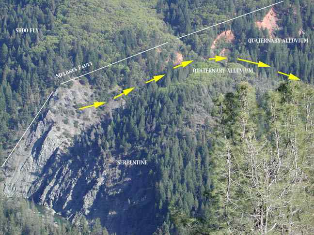
This photograph was taken from the north
side of the canyon, looking to the southeast. Note the North Fork
at lower left. The yellow arrows mark a relict channel of the
North Fork American, and below the arrows, near the center, a
grove of Kellogg's Black Oaks can be seen on the summit of Snakehead
Point (one of the bedrock knolls of Green Valley). The oaks are
serpentine-intolerant and mark the position of the high gravels
of the Hayden Hill Mine, fully 600 feet above the river. In the
background, hydraulic mining scars can be seen. The oak-grove
gravels are exposed in cross-section on the far side of the knoll.
While there seems to be some rationale for assigning a Sherwin age (>760 ka) to the gravels of the Hayden Hill Mine at Snakehead Point, I wished to make a somewhat different point. Suppose the Sherwin to have been a more extensive glaciation than all those since--should we not expect more rapid canyon incision during such an episode? It seems only reasonable. Riebe and Kirchner arrived at incision rates of between 6 and 20 inches per thousand years for a portion of the Feather River; we found a rate of 5 inches per thousand years, by dividing the (roughly) 6 million years since the last andesitic mudflows were laid down, by the 2500-foot depth of the North Fork canyon at Giant Gap. However, again, I myself can not accept 50 inches of incision in Giant Gap during the 10,000 years of the Holocene. So, what? I can only imagine that, while the 5 or 6 inches/ka may be well and good on average, that in detail, the rate varies; that it increases during glacial maxima, and decreases during interglacials.
Add to these uncertainties, that since, all other things being equal, steeper gradients mean faster channel incision, as the Sierra has been uplifted, this has tended to increase incision rates. The crest of this part of the Sierra has been elevated three to four thousand feet within the past "six million years"--i.e., since our hypothetical beginning of the incision of the North Fork canyon.
There is so much left to learn about Sierran glacial history. Take the Sherwin glaciation. The scattered deposits left here and there suggest a more extensive and robust glaciation than any which followed. Some suggest that the Sherwin may have lasted a very long time, as well. There are uncertainties here, but, from a geomorphology standpoint, were we to accept the "more extensive" and "of greater duration" attributes of the Sherwin, it may well follow that a disproportionate amount of canyon incision occurred in Sherwin times. It is possible that the Sherwin valley glacier in the North Fork American, for instance, extended miles downstream from Green Valley, and that just to the north, in the Bear/Steephollow canyon pair, Sherwin-age valley glaciers extended west beyond Dutch Flat. This is the merest conjecture; for all of having hiked these hills for over 25 years, I can report no bodies of till west of Green Valley or Dutch Flat. However, the divide between the Bear and Steephollow is suspicously well-wrecked. Where so many other ridges in the area preserve long flat summits, remnants of the volcanic mudflow plateau, the divide between the Bear and Steephollow has only fragments of mudflow left along its crest. The ridge's profile is full of ups and downs.
It should be remarked that the Bear/Steephollow canyon pair derived overflow ice from the South Yuba basin, just as did the North Fork American. Thus these canyons were artificially deepened, in a way, for their own basins are not large enough, nor high enough, to collect enough rainfall or enough ice, to account for their present depth. Tioga-age moraines are found in the Bear river canyon around ten miles east of Dutch Flat, and very weathered bodies of glacial till are found on the ridge between Steephollow and the Bear, around five miles east of Dutch Flat. By "very weathered" I mean that the granitoid boulders--which were ripped from the South Yuba basin, incidentally, and which are white and sound and fresh on Tioga moraines--are punky and stained red with iron oxides, in these older tills to the west.
No one knows how old these weathered, iron-stained tills are. Similar depositis are found on Sawtooth Ridge, the divide between the North Fork American and the North Fork of the North Fork. Here again the flat-topped mudflow summit has not been preserved intact, only isolated fragments remaining, and here again there was ice overflowing from the South Yuba basin, not only into the main North Fork, but also into the North Fork of the North Fork and all of its tributaries. Here again, were the North Fork of the North Fork to be eroded only by waters and ice peculiar to its own basin, we would not expect to find it as deep as it is. Yet it is deep, and its channel is well-graded to that of the main river. There is glacial polish on the Shoo Fly slates at Helester Point, and weathered till a few hundred yards west of there, atop Sawtooth Ridge.
Now, this glacial polish and this weathered till are of an unknown age, but the till is so unlike the fresher depositis of the last, Tioga glaciation, that it must be older. On the other hand, it cannot be Sherwin till, for there is just no way that a body of till could be preserved upon that narrow ridge crest for over 760 thousand years. We may as well imagine the till to be Younger Tahoe (65-70 ka) in age.
All of this is only to imagine, only to guess. What we need is field study, mapping, measurement, cosmogenic dating, soil evaluation, carbon 14 dating, in fact, the whole arsenal of approaches suited to dating outwash terraces, tills, and moraines. What I was reaching for, in the above, was the idea of a Sherwin glaciation which did the lion's share of canyon deepening and widening; so that, if anything, subsequent glaciations performed less work in shaping the landscape, than one might expect from their own volumes of ice and of meltwater and abrasive sediment loads; less work, because the Sherwin had done so much; the paths were already carved, the way was already smoothed, the canyons were already deepened.
Certainly some glaciations did more work in the way of erosion than others. In Green Valley, we find masses of sediments of apparently many ages, on both sides of the river, along with relict channels in the serpentine bedrock, some of which closely parallel the current channel and are nearly as deep. The sediments range in character from unconsolidated glacial outwash, with large boulders in a sandy matrix, to beds of clay, to strongly cemented gravels, to strongly cemented "agglomerates," these last sometimes standing very high above the river. In at least one case, a mass of cemented agglomerate is fully 800 feet above the river. I call these deposits "agglomerates" because they are formed mainly from angular, unrounded clasts of rock. It is notable that these agglomerates contain rare rounded boulders of andesite, which rolled down, apparently, from the mudflow capping the ridgecrests hgih high above.
The cemented gravels of Green Valley are a subject unto themselves. Some are made of mainly rounded clasts, and are slathered over polished serpentine bedrock at river level. They look somewhat as though a load of cement had been dumped along the river and polished smooth. Then again, there are masses of such cemented conglomerate stuck to the cliffs visible on the left of the photo above, about 100 to 150 feet above the river. The cementing agent for the conglomerate and agglomerate is unknown. It may be iron, but the overall color of the cemented deposits is gray to dark gray. Upstream, near Euchre Bar, there are bodies of weakly cemented gravel, freshly exposed by the January 1997 flood event, which are red with iron oxide. The conglomerates and agglomerates of Green Valley seem to be something peculiar to that area, and almost certainly are linked to the serpentine bedrock there. It is reasonably clear that, in order to have been so strongly cemented, these agglomerates and conglomerates must have been buried and subjected to saturation with mineralized groundwater.
The presence of the cemented conglomerate at today's river level is significant. It shows that the current channel of the North Fork American is, at least in part, an exhumed older channel. Since the Tioga glaciation is known to have been marked by several distinct advances, perhaps the initial incision of this channel, its subsequent burial, and its exhumation alike, are all Tioga events.
There are also strath terraces in Green Valley--terraces cut directly into the serpentine bedrock, when the river flowed at a higher level, during one or another of the burials of Green Valley beneath glacial outwash. In fact, north of the river, the flattening of the topography below the 2200-foot contour is quite notable. This flattening suggests that this entire broad area was repeatedly buried beneath glacial outwash gravels. Locally, masses of these outwash sediments remain. Elsewhere, they have been stripped away by erosion.
Several tree species are quite serpentine-intolerant; for serpentine acts almost as a poison to many plants, in part reducing the ability of plants to take up water from the soil. Pondersoa Pine and Kellogg's Black Oak are almost vanishingly rare in serpentine soils, yet, there is a thriving forest of Ponderosa pines in Green Valley. These stands of heavy timber mark masses of glacial outwash sediments. The more lightly timbered and brushy areas, where one often finds the Digger Pine, mark areas where the outwash sediments have been stripped away down to the serpentine bedrock. This pattern is especially true north of the river, where the south-facing slopes accentuate warmth and dryness and thus act to enhance the water-robbing "poison" of the serpentine. On the south (north-facing) side of the canyon, much more forest cover has developed on the serpentine, with deeper soils better-suited to holding water.
Go to my Sediment Gallery to see photographs of the various terrace gravels, strath terraces, cemented sediments, and so on. I also hope to begin to make a precise geologic map of Green Valley.
It is notable that the Quaternary gravels of Green Valley are "auriferous" (gold-bearing) gravels. This should come as no surprise, since as mentioned above, all the "bars" worked so diligently in the Gold Rush, with names like Murderer's Bar, Mineral Bar, Pickering Bar, Fords Bar, and so on--all these bars are terraces of glacial outwash. In Green Valley, the volume of these outwash gravels was such that hydraulic mining was brought to bear in several locations. Elsewhere, ground-sluicing was used to mine gold from the glacial outwash. Most of this mining occurred during the 19th century, but some persisted into the 20th century. The mining has served to destroy some terraces we might wish had remained intact, from a geological standpoint. In other places, mining has exposed the terrace gravels in cross-section.
Below, you will find a collection of old newspaper articles bearing upon the mining history of Green Valley.
The early history of Green Valley--say, from 1849 to 1862--remains quite elusive. There ought to be newspaper articles; there ought to be diaries; there ought to be letters, to families back in "the States"; but I have been unable to discover any such sources. In the 1860s, it is mentioned in newspaper articles that Green Valley had a population of "thousands" or of "two thousand" in 1851 and 1852. This would promote it to the highest ranking, among the old placer mining camps along Sierran rivers.
Part of the history of Green Valley is the history of the Chinese in Green Valley. As we shall see in another item, rich strikes were made, and claims were jumped. This short article, from Auburn's Placer Herald, offers a sanitized glimpse of the situation:
Placer Herald
January 21, 1854
Miners' Meeting
Green Valley, Placer Co., Jan. 1st, '54.
At a general meeting of the miners, called
pursuant to public notice, and holden at Messrs. Wattles &
Granger's store, Morris King was chosen chairman and John K. Cate
appointed secretary. Upon the organization of the meeting, Robert
Smith arose and stated the object of the meeting.
Mr. Smith offered the following resolution:-
Resolved, That no Chinaman shall be allowed,
from this date, to hold any mining claim, or to work upon any
claim in the district of Green Valley.
An amendment was offered thereto by Mr. Louis
Baugher, that in case of the expulsion of the Chinamen from this
district, that any claim holden by them should revert to the miners
at large. The amendment was lost.
Upon the original question being put, it was
unanimously decided in the affirmative.
On a motion being made by Mr. John Harden,
that R.D. Granger be appointed Recorder of Green Valley, and being
duly seconded, the same was carried unanimously.
The meeting was then adjourned until the 1st
Sunday in March.
Morris King, Chm'n.
John K. Cate, Sec'y.
The following article, from the 1862 Dutch
Flat Enquirer, informs us of the motivation for the earlier
exclusion of the Chinese from Green Valley. The author, who signs
himself Agesilaus, is engaged upon a survey of active mining
camps in Placer County, and has in previous issues of the Enquirer
touched upon Dutch Flat and Gold Run. He next visited Lost Camp,
and now marches to Blue Bluff and Green Valley.
Dutch Flat, Nov. 17, 1862.
Mr. Editor:--I
left Lost Camp on the morning of the 17th of October, for Blue
Bluff, which lies in a southward and easterly direction and about
six miles from Lost Camp. The trail by way of the ditch, for about
three miles, is very good, but the balance of the route, is mighty
rough. I made the trip in about two hours. This is a small mining
camp, receiving but little notoriety in that line from the fact
that the most necessary commodity (water) is almost as valuable
as golf. There are but three claims here,-and they will be worked,-one
drift claim, the "Wild Yankee," and two hydraulic claims.
These claims have plenty of fall for running tailings, as they
empty into Blue Canyon, which is but a short distance from these
claims. The only available water in this locality is what can
be collected during the rainy season. Large reservoirs are built,
which receive the water from the hills, hill-sides and ravines
in such abundance that it enables them to wash for about five
or six months in the year. Could there be an abundance of water
supplied to this section there is no doubt but one hundred men
could be remuneratively employed for a term of years. One of the
owners in the "Wild Yankee" informed me that the whole
"bench," extending for at least two miles, meandering
along [lacuna] surface, which is alluvial, and filled with quartz
boulders and pebbles and washed gravel, the texture of which gives
indications of gold wherever found. There are but three families
residing here, and when taking all the advantages (both material
and artificial) into consideration, it is fair to presume that
this number will not be greatly augmented in the next two years
to come. Finding nothing of further interest in this place I wended
my way for
Green Valley.-This
is quite a mining camp, lying on the North Fork of the American
river, which I should judge was about six miles from Blue Bluff
in a southerly and still more easterly direction, and about as
rough a trail as can be found in these parts. After traveling
this distance, from Lost Camp to Green Valley, which I accomplished
by 12 M., I came to the top of the hill which overlooks, and being
at least 2000 feet above the village, I found nothing but a "lumber
trail" by which to work my descent. This I found so steep,
for at least one-third of the distance, that I was compelled to
use by back as a sort of sled very much to the annoyance and discomfiture
of your correspondent. Everything brought to this place for consumption
must be packed, as it is an impossibility to reach that spot with
a wagon. One thing, however, is very much in favor of those who
live and mine there--they are not troubled by much snow. There
are but three families residing here; and it appears that they
reside at this place simply because the male portion can find
employment in the mines. As to agriculture here, it is not worth
mentioning. It is possible that beans, potatoes, beets, onions,
etc., to a limited extent, might be raised but nothing else.
At this place I met with a hearty welcome.
Messrs. Ford, Barber, Carr, and others, did the "amiable."
Mr. Barber keeps the only public house in this place, which he
had been prevailed upon to start but a few weeks since. A house
of this class is always considered indispensable in a spirited
mining camp like this, and I think they have got the right man
in the right place.
There are sundry claims being worked here,
and all render satisfactory returns. Five hydraulic claims will
be worked this winter; and if water could be procured, two additional.
The best claims here are one owned and worked by Hall & Opel
and the other by Handy & Shearer, both of which are very rich.
There are usually at work, during the summer season, about sixty
men, and in winter about twenty-two, besides an endless number
of Mongolians. The celebrated China claim, which was worked in
1853 and $100,000 taken out, and was jumped subsequently by a
party of white men who worked it a season or so without taking
out enough to pay expenses, has again been taken up by the Chinamen
and is being worked with satisfactory results. This is a river
claim, running from bank to bank, furnishing from ten to twelve
feet of pay dirt; and from what I could learn they will not be
likely to work it out this season.
Thus far in my travel I have not seen a church
or schoolhouse. Although there are many families and children
in proportion, there appears to be no anxiety on the part of parents
(at least I have no evidence to the contrary) to afford the rising
generation any better advantages than the "gude wife"
can bestow.
Agesilaus.
The 1866 Sacramento Union refers to Giant Gap as Jehovah Gap, a curiosity, apparently ephemeral, for this is but one of two such references I have ever seen, and the only one in my files. The controlling "Saxon and Celt" are the Americans (of English and Irish descent) who superintended the toil of the "Celestials" (Chinese).
Sacramento Union
August 14, 1866
The Advance of the Iron Horse
The work upon the line of the Pacific Railroad between Alta and
Cisco, a distance of twenty-three miles, is so far advanced that
there can be little doubt of the iron horse reaching Cisco, a
point ninety-three miles from Sacramento, in October. Beyond Alta
the grading is finished to Canyon Creek, where a large force is
employed in building a long and high embankment over a culvert
of costly masonry. Thence, for a distance of nine miles, the road
is ready for the track. On the remainder of the section there
is only one cut that causes delay, and that will be completed
about the time the grade at Canyon Creek will admit the passage
of a train. The work of railroad building in this lofty and rugged
region-ascending from thirty-six hundred to nearly six thousand
feet above the sea-is very heavy-a succession of deep cuts and
huge fills; but the host of Celestial laborers, under the energetic
control of Saxon and Celt, is so numerous that the mountainous
obstacles are "here to-day and gone to-morrow." The
scenery along the route of this section is grand indeed. Four
miles beyond Alta is Jehovah Gap, between high and precipitous
mountains, through which, on a clear day, the traveler may see
the green foothills, the tawny plains and the glittering thread
of the Sacramento. Above the Gap, fifteen hundred feet below the
railroad grade, is Green Valley, where several thousand miners
found employment in the flush days of gold-digging. The valley
looks like a very narrow ravine, and the ranches along the line
of the river appear like the diminutive gardens of a child's play-house.
The Summit of the Sierra appears from this point to be a pleasant
goal for a morning's ride. The iron horse will go over that crest,
with a snort of triumph, next Summer; but there is a vast work
to be done in smoothing his pathway before he can reach the icy
waters of the Truckee and greet the impatient dwellers in the
silver-land.
From Auburn's Stars and Stripes, I have this mention of the "2,000 men" of Green Valley. I will not comment upon the problems presented by his geological terms and ideas. At any rate, the channel he describes is high above the present North Fork American, at about 3600 feet in elevation, and the tunnel mentioned is high on the west side of Giant Gap Ravine. Of course, his "Nevada" is our "Nevada City."
Auburn Stars and Stripes
February 13, 1868
The Blue Gravel Ranges
of Placer County
A correspondent who signs the initials "A.H.N."
has favored us with the following communication upon a subject
of great interest to the people of Placer, and we cheerfully give
it a place in our columns.
Iowa Hill, February 10, 1868.
Mr. Editor: That there are vast ranges of blue
gravel deeply buried under a volcanic lava in the upper or eastern
part of this county, there can be no doubt. This range, so far
as discovered, crosses the North Fork of the American river at
Green Valley--the celebrated Giant's Gap, just below, a solid
wall of blue trap-rock--and seems to have formed a part of the
western rim of this ancient channel. Across this channel and through
this neck, the present stream has made its way. Green Valley has
been one of the richest mining camps in the State--2,000 men being
employed in '51 and '52 in mining for the gold that was here deposited
from the old channel or blue gravel range. The gold taken out
at this point was entirely different from what is now found in
the claims at Gold Run and Dutch Flat, but was very coarse and
heavy, similar to that found at Iowa Hill, Todds Valley, Georgetown,
etc., on the eastern side, and also like that found at Blue Canyon,
Blue Bluffs and Nevada on the western side, showing that this
channel ran in a northwesterly and southeasterly direction and
crossed the Middle Fork of the American river at or near Forest
Hill and Georgetown. From the vast amount of gold that was found
in Green Valley (several millions of dollars), it is certain that
this channel was very rich. To trace the lead on the east side
of the river and to try and strike the old channel in the hill,
a company was formed by Nahor, Lund & Co., two years ago,
called the "Giant's Gap Co." Their tunnel is now 215
feet in length, and they have already found traces of an ancient
channel some 500 feet in width. The tunnel was run in on the bedrock
with a high rim on each side, and is some 600 feet from the top
of the mountain. This deposit is composed of volcanic lava, scoria,
etc., cemented harder than the rock itself, and has buried the
old channel hundreds of feet below the present surface. There
has been found in this tunnel (600 feet from the present surface)
perfect roots of trees, in such a state of preservation that on
being dried they will burn like punk. These roots are found curled
and twisted just as they grew, in a soft blue cement between the
hard volcanic lava and bedrock. There have also been found washed
quartz boulders, drift-wood, etc., and this summer will probably
open up some of the richest claims in the State, and develop a
range of gravel miles in length and several hundred feet in width.
If capital and labor could be induced to take hold and open up
these buried treasures of the State, there can be no doubt but
in time, with the present rates of labor, these mountains will
yield immense dividends to the lucky owners.
A.H.N.
From 1875 to 1878, and continuing sporadically into 1881, the Dutch Flat Forum recorded the local news. Quite a few mentions of the mines in Green Valley are found in the Forum. In this letter, we learn about the Green Valley Blue Gravel Mining Company; note that the lumber slide is again mentioned, which we first met in the 1862 letter of Agesilaus. This lumber slide may have been in the gully just east of Casa Loma. Also note the description of the flume across the river, at the end of the letter; this could only be on the ditch which runs through the gorge between Euchre Bar and Green Valley, and leads to the hydraulic pits at the west end of Green Valley, near The Pyramid. The ditch took from the main North Fork, about one mile upstream from its confluence with the North Fork of the North Fork.
March 2, 1876
The G. V. B. G. M. Co.
Alta, Feb. 27, 1876
Editor of the Forum: The subject of which the above caption is an abbreviation,
appeared in the Forum Feb. 3d, together with a promise to give
additional particulars at some future time. An invitation by the
Supt. (S.V. Souder) to visit the mine has been accepted, and thanks
are due him for kind treatment and interesting items. The very
accommodating and ingenious philosopher of the Alta dispensary,
who emulates the far famed Dr. Franklin in bottling up lightning
fluid, (now known as "crooked") volunteered to furnish
a quantity, warranted to facilitate locomotion. Having accepted
a couple of "spurs" before starting, the motive power
proved complete to a point on the C.P.R.R. where it was decided
to descend to Green Valley. Here passage was taken on the lumber-slide,
and by a vigorous application of the brakes, made a successful
descent. "Innumerable myriads of robins" were not observed,
being too busily intent on finding the end of the trail. On arrival
at the camp an excellent dinner was prepared by Mrs. Phetteplace
who reigns Queen of the culinary department and who is highly
esteemed as an accomplished lady, and a good cook. Green Valley
is a little world by itself, the area approximately 2/3 of a mile
wide by one mile in length. Being far below the surrounding lofty
summits, the rays of the sun are concentrated to a degree which
makes it almost perpetual summer. Here energetic and persevering
miners have succeeded each other in faithful search and toil year
after year to possess themselves of that precious metal which
nature has long since buried there. The Co. now under consideration
commenced hydraulicing the first of June 1875 with a four inch
giant at the lower end of their claim. After cutting through the
rim-rock and extending their flume up the river 240 ft., it was
found that a ten foot dump had not the capacity to accommodate
the tailings and wash to as low a grade as desired. The bank being
about seventy feet high and the lower half mostly sand, it was
decided to wash off the heavy rock and gravel through another
cut higher up the river. Cut number two they commenced, leaving
twenty feet for dump, and blasted through 130 feet of bed-rock
over twelve feet deep, and after extending their flume 324 ft.
on a seven inch grade at right angles with the river, they had
about 35 feet of bank. From this point they worked down and parallel
with the river to connect with cut number one, the distance being
about 300 feet. A flume 39 inches wide is now in 84 feet of the
distance, and when the connection is made will leave a bank of
about 40 ft. It is the intention to wash 200 ft. wide, with a
branch flume, and then return to the place of beginning and wash
to as low a grade as possible. When this is accomplished, hoisting
works will be erected and a shaft put down to bed-rock, which
is presumed will be about 30 ft. The channel will then be thoroughly
prospected by running tunnels, which will decide the fortunes
of those who have invested in this great mining enterprise. The
Supt. is confident that he will be ready to commence the shaft
by the end of next June, which will be 4x8 ft. with two compartments,
one for hoisting gravel and the other to run a 10 inch Cornish
pump which will be done with an undershot water wheel 16 ft. in
diameter, having an estimated 30 horse power. T.A. Wilson is now
foreman for the Co., and the work under his direction is progressing
rapidly. He has just completed laying down a string of new 15
inch pipe, and placed a No. 2 giant in position which, in addition
to the first, and using about 1400 inches of water, forces the
gravel to take a rapid forward march to the sea. Ten men are employed
who work the claim night and day, and, having a strata of gravel
which prospects well, it is thought that it will pay expenses
this run. The disbursements of this Co. since active measures
were taken to construct a canal, up to the present time, has been
between $60,000 and $70,000, while the receipts have been but
$1800. The experience of merchants and laborers who have had business
with this Co. is of such a nature as to command their respect
for fair dealing, good wages and prompt payments. A narrative
of the Co.'s proceedings have been given in detail, owing to the
obscure location of the claim, and a disposition on the part of
a few persons to misrepresent things, and also to satisfy a natural
desire of the mining community to become acquainted with the progress
made in a great enterprise.
Another important and interesting item which
has not been mentioned, is the trestle-work erected on the bridge
to convey the water to a corresponding height on the opposite
side of the river. The height of the bridge as before mentioned
is 62 ft. from the bed of the river, and the trestle-work is 73
ft. up to the bed of the flume, making in all 139 ft. to the top
of the flume. The American River at this point on its bed is about
40 ft. wide, and when its rushing waters are at their height and
come plunging through this narrow gorge, it forms a scene, when
viewed from a central position over the river, which would well
repay those who admire the grandeur of nature together with the
remarkable achievements of science and art.
Zimri.
Again from the Forum, we discover George Opel an owner of the Hayden Hill Claim. This is the mine which has left the large red scars and huge tailings-piles of boulders, above the south bank of the river, in the middle of Green Valley. It is this mine also which has been the subject of a persistent rumor, that many Chinese miners (and their sluice box) were buried in a slide. I have been unable to verify this story.
Dutch Flat Forum
May 4, 1876
Green Valley Mining Items
We learn by parties from Green Valley that
the G.V.B.G.M. Co. is making rapid progress in removing the gravel
to the lowest grade, and will be ready to sink their shaft in
about three weeks. Astonishing results are expected when this
mine is developed and the prospects, labor, and expense, all go
to justify the conclusion.
The Hayden Hill Claim is owned by Geo. Opel,
Jas. Ross and the heirs of John Hall. Geo. Opel is the Superintendent.
This claim is situated on the south bank of the North Fork of
the American River, and is 500 feet above the present channel,
and directly opposite the Green Valley Mining Company's claim.
This Company owns 60 acres of ground with an average depth of
gravel of over 100 feet. They employ seven men and use 500 inches
of water, from two canyons a distance of 112 miles from their
claim. They hydraulic throughout the entire winter and clean up
in the summer, which keeps them at work the whole year. The claim
pays well.
The claim of Harper, Howthorpe & Co. is
situated 112 miles below the above named claim, on the South bank
of the same stream. This company spent a great deal of time and
money during the past season, in running through the rimrock to
fit up for hydraulicing the present season. They have their own
ditch which is capable of carrying 500 inches of water. An average
of four men are employed, and when once under headway good clean
ups are expected, because the prospects justify this belief.
The Norvey claim is situated on the North Bank
of the river and is a large mining territory, more perhaps than
the present company will be able to get away with. They use 300
inches of water which is taken from two gulches nearby, one of
which is owned by Geo. Opel, and the other by the company. Good
results are expected.
The Beardslay Claim is run as a hydraulic claim
in the winter, and as a drift claim in the summer. The claim embraces
a large bar in the river. Four men are employed, taking out big
pay.
There are several other claims in this locality,
of which we shall take occasion to speak at a future time.
In the pages of the Forum we find this early description of a visit to Lovers Leap:
June 15, 1876
The prospecting party that started out last
Thursday week under the supervision of Messrs Frost and Brannin,
in search of scenery for stereoscopic views was a success, so
far, at least, as magnificent scenery was concerned. Immediately
after leaving Alta, a few sharp turns, the road hugging the mountainside,
we arrive at a point overlooking the Green Valley Mines, and where
finer scenery could not be found in California.
Here are the rocks towering above us, and we
are on the verge of a lofty height, with a sheer wall below us,
down which we glance to the chasm 2,600 feet, where houses are
dots and men mere specks on the earth's surface. There winds the
American River like a belt of precious metal, as its yellow waters
glisten in the sun. To the right and the left ... the great canyon,
dark, hazy, rich in foliage, awful in depth and distance, opens
up to the vision and then diminishes, and is lost in its own shadings
miles away, while the mountains forming its walls rise far above
and beyond us, and the forests on their tops fringe a new and
elevated horizon against the sky. It is a glorious scene. We stand
upon the precipice and it seems as though an easy spring would
send us clear off the wall upon the green turf below. About us
tower giant mountains, peak upon peak, crest upon crest, crowned
with forests of living green, and beyond all the snow-capped Sierra
in the far distance appear and disappear in the mists and clouds
which play about their heads. At our feet are wooded slopes and
a smiling vale; a turgid river and a bright sunlight relieving
both from the gloom and shadow of the awful hills. We no longer
wonder at the enthusiasm of artists over Placer County scenery,
no longer wonder at the utter failure to depict in words of grandeur,
beauty, and inspiration of the scene, and as we move on new points
of view and new glories of scene open up. To the right and the
left are to be seen evidences of man's conflict with the hills
to make them yield the precious ores. In the distance on the mountainside
is seen the Central Pacific, whose train climbs with labored effect,
every foot of which is a marvel of engineering skill. But as the
subject is inexhaustible we may as well stop right here by adding
that all the pleasure derived from the trip was like any other,
gained by overcoming many difficulties. Who ever heard of anyone
having a good time but what they paid dear for it. Nevertheless,
we all got what we went for and tarried till 'Twilight let her
curtain down, And pinned it with a star' which was the only warning
we had that it was high time to leave, which we did in less time
than it takes to pen this, and the party, numbering about fifteen,
join in one accord in saying that the day was pleasantly and profitably
spent.
From the Dutch Flat Forum, we obtain evidence of a claim distinct from the Hayden Hill, called the "Opel claim." The buried Quaternary channels in Green Valley often called for the construction of shafts and drain tunnels. Here too we find mention of the amazing cemented Quaternary gravel of Green Valley, for which stamp mills were required.
February 1, 1877
Green Valley Mines.
The Opel claim.--There has been a great deal
of work done in this mine since our last mention. The loose top
ground has all been washed off and a shaft raised from the bedrock
tunnel, through which they have been washing for some time, receiving
their supply of water from the Green Valley Mining Co. This ground
is said to be very rich, as gold can be seen in the bank they
are now washing, something uncommon in hydraulic mines.
Hayden Hill Co.--This mine is being worked
under the supervision of James Ross, one of the owners. They have
been busily engaged in the past few months getting it into shape,
during which time there have been several necessary improvements
added to the works connected with it. A large head of water is
now used, and the work of removing the gravel is progressing rapidly.
This mine payed a large dividend last year, and the chances are
in favor of its paying an even larger one this.
Norvey Co. have their cement mill built and
in readiness to commence crushing, the tunnel is also completed
and the work of raising a stope will be finished in a few days,
when the mill will be started up and kept crushing what is said
to be very rich cement. It is also extensive.
We now turn to the pages of the Colfax Sentinel, in the period 1894 to 1896. We first encounter another stamp mill, at the Gold Ring Mine, which is situated at the base of Giant Gap Ravine; a log cabin, from the 1930s, stands there today.
January 26, 1894
Mining Briefs
The mill at the Gold Ring mine at Green Valley
is now ready for operation and will be crushing cement next week.
Superintendent Ames is an expert millwright and has considerable
experience in setting up mills. It was an extremely arduous task
to bring the heavy machinery down from the top of the mountain
ridge on the Iowa Hill side, down to the river thousands of feet
below. A chute was built for this purpose and the ponderous mortars,
and other heavy machinery were thus taken down. It was quite a
feat, and that the mill is all ready for work is due to the skill
and energy of Superintendent Ames and his efficient foreman, L.C.
Jacobs. Over 600 feet of 8-inch pipe have been made on the ground,
and nearly 700 feet of ditch dug, in order to gain the power for
the mill. The Gold Ring gives every promise of becoming one of
the paying mines of Placer county.
The Chinese of Dutch Flat were not only miners, soaproot-diggers, railroad-builders, and grocery store proprietors, but engaged in packing goods to the far-flung mines of the area.
June 22, 1894
Dutch Flat Happenings
Narrow Escape From Drowning.
Ah Mung, who is well known and popular in these
parts, had a very narrow escape from drowning in the American
river one day last week. Mung was raised here and is a bright
and enterprising Chinese boy and is the owner of several mules
with which he packs goods to the Gold Ring Mine at Green Valley.
On one of his trips last week he tied his mules together and attempted
to cross the river. He passed through with his riding horse without
any difficulty and tried to lead the mules across but when they
reached midstream they were washed down, pulling him in with them.
While holding on to the ropes he became entangled in them and
was carried along with the mules. They were carried down the river
about one hundred yards, when he freed himself from the ropes
and swam ashore. He succeeded in getting the mules out on one
side where a trail had to be dug in order to rescue the animals.
Although he swallowed a great deal of water, he was able to return
home safely. Out of three mule loads of provisions, powder and
mail, etc., but little was saved. The loss is about twenty dollars.
Work in the gold mines was quite dangerous.
November 16, 1894
Dutch Flat Items
A Fatal Mine Accident.
Benjamin Barber Loses His Life.
A sad accident occurred last Friday at Green
Valley near this place. Two youngmen, Charles and Ben Barber,
were at work in the claim of their step-father, Geo. Opel, running
a bedrock tunnel. They found a streak of soft rock that gave them
considerable trouble to hold back and after timbering and getting
it under control, continued driving ahead. While fixing the track
a short distance from the face Friday morning a piece of rock
weighing several hundred pounds came from the side crushing Ben
to the bottom of the tunnel and killing him instantly. Charley,
who was but a few feet from his brother, was caught by the foot
but managed to pull his foot from the boot and escaped with a
few bruises. He went to the Gold Ring mine and gave the alarm.
Superintendent Ames, with a force of men, hurried to the mine
and removed the mass of rock and recovered the mangled remains
of Ben. Mr. Ames brought the body to Towle when a telegram was
sent to this place where the mother of the two boys was visiting
her daughter, Mrs. J.W. Jameson. The body had to be carried out
on the pack train that runs to the Valley, as it is about 2000
feet from the top of the ridge and a rough mountain trail to come
over. The deceased was aged twenty-two years, and was born and
raised at Alta where his parents have resided for many years.
The funeral took place here Sunday under the auspices of the I.O.O.F.
and N.S.G.W., of which orders he was a member. His pleasant manners
and upright doings in life made him a general favorite with all
who knew him, and many were the friends of himself and family
who followed the remains to the city of the dead to pay the last
respects to one taken from our midst in the prime of life. Mrs.
Opel and the members of the family wish to return their heartfelt
thanks to Mr. Ames and the men who kindly assisted in doing all
they could at the time of the accident and to all others who lent
a helping hand or gave a kind word.
Whenever gold is involved, quarrels are not long to follow.
January 18, 1895
Dutch Flat Chinatown
on the Verge of War.
This has been an off week for news. Society
has been at a standstill owing to the stormy weather. No one ventures
out unless on business of importance. A change in the weather
Tuesday night gave us 18 inches of the beautiful for a morning
surprise, and at the present writing it is still snowing. So we
may have a small winter yet.
Chinatown has been on the verge of a small
war the past few days and all the members of the two companies
involved go heeled "allee samee Melican bad man." The
trouble originated over the leasing of a claim in Green Valley
owned by white men. One of the China companies have two shares
and the other holds one share, and they are both trying to work
the claim. Fong Ah Kite had three of the Wee Kee men arrested
for threats to do the said Ah Kite up and send him higher than
the name he bears. The case comes up on the 29th and some tall
swearing may be looked for. Deputy Constable Morrison came up
from Colfax and arrested On Gee, one of the Chinamen of the Wee
Kee company, and took him to Colfax. Bail being furnished for
his appearance at the trial Friday, he was allowed his liberty.
He says Colfax not much good house to sleep.
Gleaner.
Here we find the Chinese prosecuted for (illegal) hydraulic mining, and an old resident of Green Valley coming to their defense.
April 17, 1896
Chinese Arrested in Green Valley
Dutch Flat, April 13, 1896
Editor of the Sentinel:--The public interest
in the recent arrest of Chinamen in this section for hydraulic
mining contrary to law is noteworthy. It is said to be the first
instance when malefactors of this sort have been taken "red-handed."
Now, I hardly think the Chinamen are entitled to much sympathy.
They ought not to be permitted to prosecute an unlawful act when
other people are prohibited. But, the circumstances ought to be
considered. I know something of this particular piece of mining
ground. I worked on it in the 1850's. I sold it to Chinamen 21
years ago, and I am informed it has been worked continuously by
them ever since. I examined it again about ten days before the
owners were arrested. It is obvious to me and to anyone acquainted
with mining that the quantity of earth washed away in all that
time is not as much as would be moved by a single monitor in the
Dutch Flat, You Bet, or Nevada City districts in a single week.
The bench is a mass of rocks from top to bottom.
It is forty or fifty feet high. It is conveniently situated for
work at a little distance above the river so that the great mass
of rocks issuing from the flumes is deposited before it reaches
the water; and even if they were dropped in the middle of the
river the current is insufficient to move them away. The sand
and gravel is so insignificant that they did not use to be and
are not now sufficient even so much as to discolor the river for
a half mile. The water used in these mines comes from springs
and small ravines on the mountain side. It is saved in reservoirs
and at best is barely sufficient for a head of about 200 inches
of water for an hour and a half twice a day. How can 500 inches
of water pass through a 3-inch nozzle with a fall of no more than
60 or 70 feet?
There are many gravel claims working in this
county by the ground-sluicing process, keeping strictly within
the law as regards place of deposit, percentage of sediment in
the water, and all other details, each one of which discharges
into streams so much more earth than the one in question that
the latter is not to be thought about for a moment. And, indeed,
it does not appear that the mining in itself can do any harm or
is objectionable, but only the manner of it. That formidable 3-inch
nozzle is liable to "overwhelm" somebody. I scarcely
need refer to the alleged effort of the Valley spies some weeks
ago to blackmail these Chinamen and their inability or unwillingness
to pay $200 to secure immunity. This has no bearing upon the argument.
N.B. Wiley
In our final scrap from the Sentinel,
we find the Opel & Williams claim purchased. The descendants
of the Dunckhorsts still retain an interest in some of this mining
ground in Green Valley. It is, I think, this tunnel where the
young man, Benjamin Barber, was killed a few years previous; and
also, this tunnel which was later worked by Joe Steiner, whose
grave is in Green Valley.
April 29, 1898
Dutch Flat
The J.G. Peters mining company was organized
in Sacramento last week and have commenced operating in Green
Valley, near this place. J.G. and Wm. Peters of our town and J.J.
Dunckhorst, S.A. Street and others of Sacramento, comprise the
company. They have purchased the Opel & Williams claim, and
will run a 500-foot bedrock tunnel to open up the claim. This
ground has always been considered one of the best claims in Green
Valley, but has never been thoroughly prospected. It is hoped
the present company will be successful in finding a good investment.
Gleaner.
Back to Russell Towle's homepage